Monday, February 20, 2006
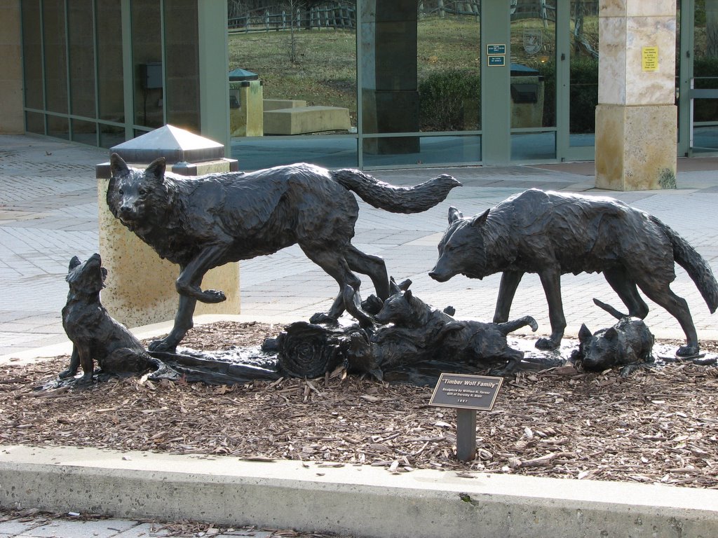
Arlington National Cemetery 02-20-06
URL to Album:
http://www.flickr.com/photos/meabbott/sets/72157605987357044/
I did not set out to go to the Arlington National Cemetery today. I went to Alexandria to see the President’s Day Parade but never made it there due to three gaffes on my part. I had planned out the trip so I would be there early and take up a spot I had selected that I felt would give me a good vantage point. However, I did not account for the time it would take for me to transfer from one subway train to the other, nor did I account for the mile I would walk from the metro station. As a result, when walked out of the subway station I headed in the direction I thought I was supposed to go without looking at the street signs (ding!) and went way, WAY off. I wound up back at the metro station and decided I had already missed half the parade and there was no point in proceeding to the parade. A train going a different direction than I planned to go arrived and I got on and headed to Arlington National Cemetery.
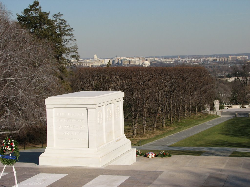
 There isn’t much to say except that it is very sobering to see the rows and rows of headstones. I had bought a ticket on the tour bus but after the first stop I decided I would walk the rest of the way. I did not see all that I wanted to see and plan to return, sans tour bus. I stayed on the road as I went between the places I went and I read some of the headstones and I knew that there was a story behind each one. The most emotional moment would have been the Changing of the Guard ceremony at the Tomb of the Unknown Soldier. I had tears in my eyes by the time I finished photographing it. This is, indeed, a very important place.
http://www.flickr.com/photos/meabbott/sets/72157605987357044/
I did not set out to go to the Arlington National Cemetery today. I went to Alexandria to see the President’s Day Parade but never made it there due to three gaffes on my part. I had planned out the trip so I would be there early and take up a spot I had selected that I felt would give me a good vantage point. However, I did not account for the time it would take for me to transfer from one subway train to the other, nor did I account for the mile I would walk from the metro station. As a result, when walked out of the subway station I headed in the direction I thought I was supposed to go without looking at the street signs (ding!) and went way, WAY off. I wound up back at the metro station and decided I had already missed half the parade and there was no point in proceeding to the parade. A train going a different direction than I planned to go arrived and I got on and headed to Arlington National Cemetery.
 There isn’t much to say except that it is very sobering to see the rows and rows of headstones. I had bought a ticket on the tour bus but after the first stop I decided I would walk the rest of the way. I did not see all that I wanted to see and plan to return, sans tour bus. I stayed on the road as I went between the places I went and I read some of the headstones and I knew that there was a story behind each one. The most emotional moment would have been the Changing of the Guard ceremony at the Tomb of the Unknown Soldier. I had tears in my eyes by the time I finished photographing it. This is, indeed, a very important place.
Sunday, February 19, 2006
Bright Sunny Day, but too Cold!
It was a bright and sunny day and the high was supposed to be 32. I figured if it actually was going to get that “warm” I would go and try the Cypress Swamp again. But the high only made it to 28. I decided that the bright sunny perfect for photography conditions just couldn’t offset the cold temperatures so I stayed inside working on some projects. Tomorrow’s conditions won’t be quite so sunny but it will be warmer. I have a couple of ideas of where I may go, so I am expecting to have something to upload tomorrow afternoon. Further on down the line I have a few places in mind that I would like to check out: Cunningham Falls State Park, Gunpowder Falls State Park and Elk Neck State Park. There are vastly more parks that are also on my mind, but you have to narrow them down to make a choice. I am amazed at how many parks of various sorts there are around here. These parks have caught my attention for the potential for wildlife viewing and photographing as well as trails. I have plenty of pictures of birds, I am hoping to spot different kinds of creatures before the leaves start growing and the range of vision drops in the woods. If I can land another bright sunny day in at least the upper 30s, I will pick one of those places and head to them. Any votes?
Sunday, February 12, 2006
All caught up Blogging my Albums
I have declared that I am now caught up blogging my albums even though I have not blogged all of them. I do not currently have plans to blog the older ones and will now blog the new ones as I do them. Most of them. I am not going to blog the snow scenes one I uploaded today because, well, there's nothing to say about it. It snowed. Voila. Enjoy.
Baltimore Aquarium 02-05-06
URL to Album:
http://www.flickr.com/photos/meabbott/sets/72157606352951878/
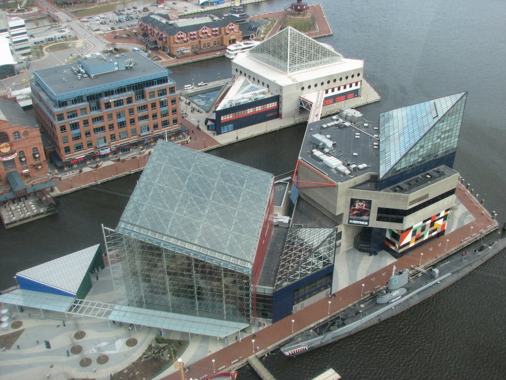
 I went to the National Aquarium in Baltimore after I heard that they have a new Australia exhibit. They actually built a new building to attach to the rest of their complex for it and while the exhibit itself is phenomenal, I am disappointed at how little of the space they devoted to it. The second floor is mainly for the shop of which they now have 3 which I think is completely pointless.
Looking through my album you will notice a lack of fish in my photographs. It was too dark to photograph most of them and I wasn’t going to use flash directly towards the animals. The photos will mainly speak for themselves and I enjoyed the experience.
I also went to the World Trade Center in Baltimore which has an observation deck on the 27th floor which offers an excellent view of downtown Baltimore. However, the windows were absolutely filthy and I was appalled that they felt it was OK to charge full price for admission when that is really what they are selling. Despite the windows I was able to get some decent shots of the area and I plan to go up there again on a sunny day to hopefully get some better shots.
http://www.flickr.com/photos/meabbott/sets/72157606352951878/
 I went to the National Aquarium in Baltimore after I heard that they have a new Australia exhibit. They actually built a new building to attach to the rest of their complex for it and while the exhibit itself is phenomenal, I am disappointed at how little of the space they devoted to it. The second floor is mainly for the shop of which they now have 3 which I think is completely pointless.
Looking through my album you will notice a lack of fish in my photographs. It was too dark to photograph most of them and I wasn’t going to use flash directly towards the animals. The photos will mainly speak for themselves and I enjoyed the experience.
I also went to the World Trade Center in Baltimore which has an observation deck on the 27th floor which offers an excellent view of downtown Baltimore. However, the windows were absolutely filthy and I was appalled that they felt it was OK to charge full price for admission when that is really what they are selling. Despite the windows I was able to get some decent shots of the area and I plan to go up there again on a sunny day to hopefully get some better shots.
North Point State Park 01-28-06
URL to Album:
http://www.flickr.com/photos/meabbott/sets/72157606383993116/
 North Point State Park is the park (map) I am the least happy with to date, mainly due to a lack of explanation of trails. While well marked like most parks, they would connect without explanation and I wound up lost and going down a trail that went away from where I thought I was going. There are signs at the parking lots with maps of the trails, but that is unhelpful while you are on the trail. At the very least the signs should exist at the ends of trails that junction with other trails. To make matters worse, the map that does exist on their website is not accurate. Most of the trails I encountered are not on this. In addition the nearly constant beeping of heavy trucks can be heard backing up. As observed by driving here, this park is near heavy industrial areas and you can hear this sound from every part of the park.
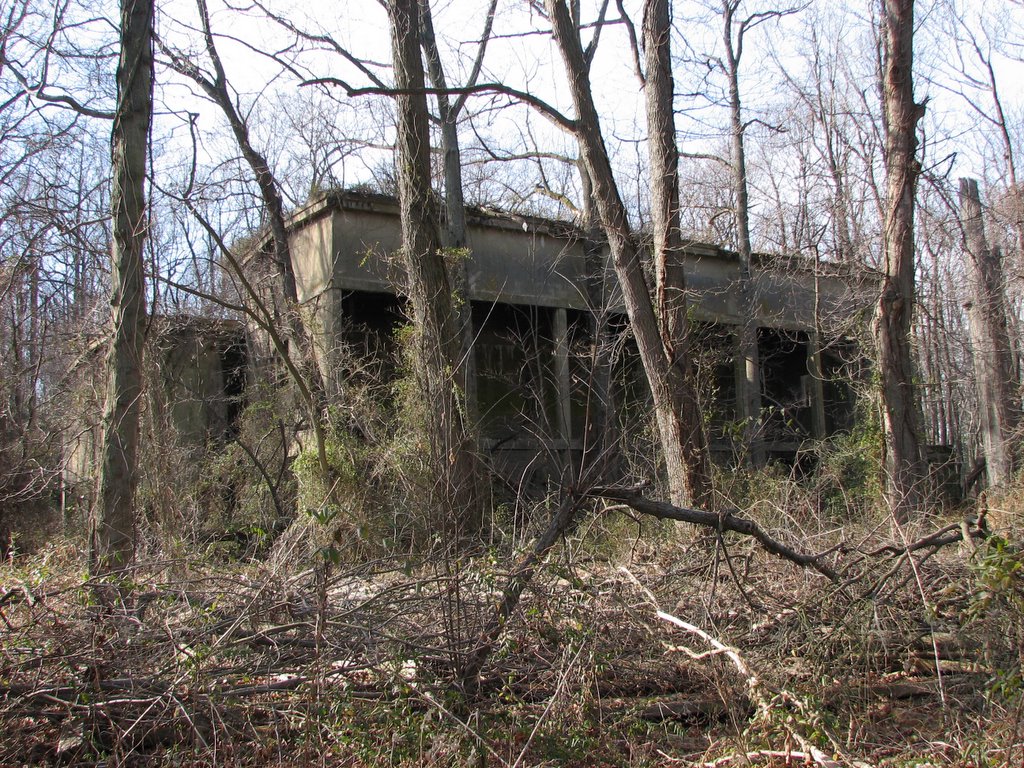
Despite all this, I enjoyed the trip to the park. There were a lot of interesting things to see. Two different lighthouses are visible from the park as well as the ruins from what I was told is an old power station that provided power to the trolley system as well as for an amusement park that had been on the property. There is a ruin of a ferry dock the power plant ruins as well. Further along where the visitor center is (closed for the season) there is what the map calls the Old Bay Shore Pier. You can walk a ways out into the bay on this earthen pier and it is a rather interesting experience. I did not see a lot of wildlife here, however I did see a bird hovering and it clearly was not a hummingbird (1 and 2). I don’t know what kind of bird this is and there’s a few more shots of it in the album for anyone curious. There is also an observation platform at the end of one of the trails and I got some nice pictures from it.
Looking at aerial photos of this place I see that I missed some photographic opportunities here and the very close Fort Howard Park which appears to have ruins of coastal defenses. I will probably come back to this park eventually.
http://www.flickr.com/photos/meabbott/sets/72157606383993116/
 North Point State Park is the park (map) I am the least happy with to date, mainly due to a lack of explanation of trails. While well marked like most parks, they would connect without explanation and I wound up lost and going down a trail that went away from where I thought I was going. There are signs at the parking lots with maps of the trails, but that is unhelpful while you are on the trail. At the very least the signs should exist at the ends of trails that junction with other trails. To make matters worse, the map that does exist on their website is not accurate. Most of the trails I encountered are not on this. In addition the nearly constant beeping of heavy trucks can be heard backing up. As observed by driving here, this park is near heavy industrial areas and you can hear this sound from every part of the park.
Despite all this, I enjoyed the trip to the park. There were a lot of interesting things to see. Two different lighthouses are visible from the park as well as the ruins from what I was told is an old power station that provided power to the trolley system as well as for an amusement park that had been on the property. There is a ruin of a ferry dock the power plant ruins as well. Further along where the visitor center is (closed for the season) there is what the map calls the Old Bay Shore Pier. You can walk a ways out into the bay on this earthen pier and it is a rather interesting experience. I did not see a lot of wildlife here, however I did see a bird hovering and it clearly was not a hummingbird (1 and 2). I don’t know what kind of bird this is and there’s a few more shots of it in the album for anyone curious. There is also an observation platform at the end of one of the trails and I got some nice pictures from it.
Looking at aerial photos of this place I see that I missed some photographic opportunities here and the very close Fort Howard Park which appears to have ruins of coastal defenses. I will probably come back to this park eventually.
Horseshoe Curve 01-27-06
URL to Album:
http://www.flickr.com/photos/meabbott/sets/72157606388663061/
 Horseshoe Curve near Altoona Pennsylvania (aerial photo) is an excellent place to watch trains. It was a cold but very sunny day when my friend and I decided to take a trip up there. It was cold but not windy. Being winter, the museum, store and funicular were closed, but we could walk the stairs up to the viewing area. There is a recently repainted and not yet lettered GP 9 on display there. We had the tremendous fortune of meeting Mr. David Seidel at the top who is the Chapter Historian for the Horseshoe Curve Chapter of the NRHS (National Railway Historical Society). While we were waiting for horsepower to muscle its way through the curve, we had an enjoyable time talking with Mr. Seidel about Altoona railroad history. In nearby Altoona there is the Railroaders Memorial Museum which is more about life on the railroad than about the railroads themselves. It has been a while since I have been there but it is a first class museum and it is still improving. We did not visit the museum on this trip, but plan to when we come back to the area. It was an excellent and enjoyable day.
Wildfowl Trust of North America 01-22-06
URL to Album:
http://www.flickr.com/photos/meabbott/sets/72157611539355868/
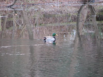 The Chesapeake Environmental Center run by the Wildfowl Trust of North America (map) is another excellent place to visit. They have a variety of different kinds of scenery from beach to wetlands to pine stands and so on. The main attraction here is the birds and there are plenty of them. When you arrive you go to their visitor center to pay the $5 entry fee (they could use better signage since I nearly walked past it). It has a big window on a pond which had geese, swans and ducks when I was there. The visitor center also has some exhibits and they had what I would call a scoreboard where they were keeping track of sightings of various kinds of birds. They also have other attractions nearby in a fenced in area such as an aviary (under repair and no birds were in it) and some “raptor mews” which contains non-releasable birds of prey (usually due to injury). One mew had a pair of owls and the other a pair of Bald Eagles. I didn’t take pictures of them because the fencing prohibited good pictures, but you can see them quite well.
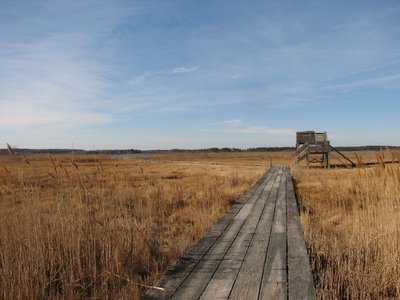 I was given a map of the facilities at the visitor center and I was able to plan my visit with it. I went first to the boardwalk over the wetlands. It has an observation tower (see the structure in the image to the left) roughly a third of the way out onto the wetlands and it provides a nice view. I would find two more observation towers on the park. There wasn’t a lot to observe from this area besides the scenery. Back down on the boardwalk I saw some small ponds in the wetlands area that have little minnow like fish in them. And the end of one leg of the boardwalk you wind up on the beach. There is a beach river there that was seemed to be draining water back into the bay that had come up during high tide. A variety of interesting patterns are present in the sand here.
 After this I walked East along Lake Knapp to the Northern end of their Marshy Creek Trail. Along the way I saw a large crane like bird coming in for a landing. It was so large and so close I forgot how to use my camera and didn’t get any pictures of it before it disappeared out of view behind the vegetation. There are two features in this area. There’s a canoe landing which is a boardwalk over the wetland that angles down to the water at the end. This is a good viewing location and I got a few pictures from here. There’s another observation tower here as well. There were no birds in view of the tower here, either, but as with the previous tower it is a very scenic view. From here I went back South along the Marshy Creek Trail to the East Blind that looks over Lake Knapp. There are two duck blinds here, the West Blind (White Blind) was closed for repairs. This is an excellent spot to view the birds on Lake Knapp.
From there I walked through the Hummock Loop Trail. There wasn’t much to see in there, but it shows the diversity of scenery on the island. It was pleasant and quiet. Next I walked to the South Meadow loop. I imagine there will be more to see here in the summer, but again, it was pleasant and quiet. I walked back south to the Piney Point path and peeked in the Woodland Pond, no birds. So I kept walking. Now, when I walk through wooded areas, I tend to stop every few feet and look around to see if I can spot something interesting. After one of these stops, I did my looking around and didn’t notice anything and took one step. I cracked a branch and about 25 or 30 feet away from me a small deer went bounding into the woods. It went so fast I didn’t have time to remember I had a camera with me. At the end of this trail there was another observation tower. More of a platform than a tower, but it was high enough to see above the vegetation and get a nice view of the surroundings. On the way back to my van I returned to their fenced in area to give it a walk around. There are three ponds in this area, but I only saw birds in one of them. There is another duck blind in there that overlooks the fence and into a small pond, also devoid of birds. All in all I enjoyed this place and definitely will return to get some seasonal shots.
http://www.flickr.com/photos/meabbott/sets/72157611539355868/
 The Chesapeake Environmental Center run by the Wildfowl Trust of North America (map) is another excellent place to visit. They have a variety of different kinds of scenery from beach to wetlands to pine stands and so on. The main attraction here is the birds and there are plenty of them. When you arrive you go to their visitor center to pay the $5 entry fee (they could use better signage since I nearly walked past it). It has a big window on a pond which had geese, swans and ducks when I was there. The visitor center also has some exhibits and they had what I would call a scoreboard where they were keeping track of sightings of various kinds of birds. They also have other attractions nearby in a fenced in area such as an aviary (under repair and no birds were in it) and some “raptor mews” which contains non-releasable birds of prey (usually due to injury). One mew had a pair of owls and the other a pair of Bald Eagles. I didn’t take pictures of them because the fencing prohibited good pictures, but you can see them quite well.
 I was given a map of the facilities at the visitor center and I was able to plan my visit with it. I went first to the boardwalk over the wetlands. It has an observation tower (see the structure in the image to the left) roughly a third of the way out onto the wetlands and it provides a nice view. I would find two more observation towers on the park. There wasn’t a lot to observe from this area besides the scenery. Back down on the boardwalk I saw some small ponds in the wetlands area that have little minnow like fish in them. And the end of one leg of the boardwalk you wind up on the beach. There is a beach river there that was seemed to be draining water back into the bay that had come up during high tide. A variety of interesting patterns are present in the sand here.
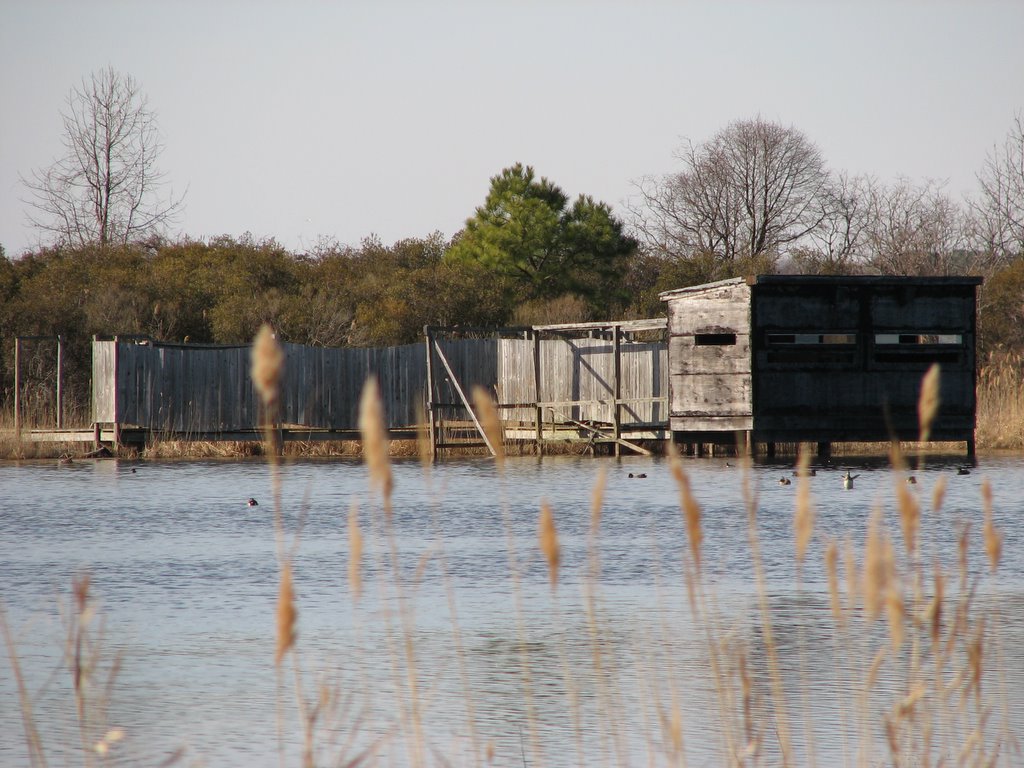 After this I walked East along Lake Knapp to the Northern end of their Marshy Creek Trail. Along the way I saw a large crane like bird coming in for a landing. It was so large and so close I forgot how to use my camera and didn’t get any pictures of it before it disappeared out of view behind the vegetation. There are two features in this area. There’s a canoe landing which is a boardwalk over the wetland that angles down to the water at the end. This is a good viewing location and I got a few pictures from here. There’s another observation tower here as well. There were no birds in view of the tower here, either, but as with the previous tower it is a very scenic view. From here I went back South along the Marshy Creek Trail to the East Blind that looks over Lake Knapp. There are two duck blinds here, the West Blind (White Blind) was closed for repairs. This is an excellent spot to view the birds on Lake Knapp.
From there I walked through the Hummock Loop Trail. There wasn’t much to see in there, but it shows the diversity of scenery on the island. It was pleasant and quiet. Next I walked to the South Meadow loop. I imagine there will be more to see here in the summer, but again, it was pleasant and quiet. I walked back south to the Piney Point path and peeked in the Woodland Pond, no birds. So I kept walking. Now, when I walk through wooded areas, I tend to stop every few feet and look around to see if I can spot something interesting. After one of these stops, I did my looking around and didn’t notice anything and took one step. I cracked a branch and about 25 or 30 feet away from me a small deer went bounding into the woods. It went so fast I didn’t have time to remember I had a camera with me. At the end of this trail there was another observation tower. More of a platform than a tower, but it was high enough to see above the vegetation and get a nice view of the surroundings. On the way back to my van I returned to their fenced in area to give it a walk around. There are three ponds in this area, but I only saw birds in one of them. There is another duck blind in there that overlooks the fence and into a small pond, also devoid of birds. All in all I enjoyed this place and definitely will return to get some seasonal shots.
Saturday, February 11, 2006
Wye Island 01-16-05
URL to Album:
http://www.flickr.com/photos/meabbott/sets/72157604479207117/

Wye Island was my next discovery on Microsoft’s mapping service. I went over there on a cold but nice day. This place is different from the other parks because it did not appear to be geared towards public use although there are facilities there for the public to enjoy. I found a trail guide on Maryland’s Department of Natural Resources website which lacked a map. It was here that I discovered that they have a very shortsighted policy of having people buy guides. So in order to get people to buy the guides, they omit the maps from the online trail guides which makes planning a trip more difficult. I would like to learn the logic behind this.
Wye Island has been my favorite spot to visit so far because it is so quiet and the variety of wildfowl present. Their trails end at coves where a variety of different kinds of wildfowl can be seen if you approach slowly and quietly. There were not very many people on the trails which was quite nice. One thing I had forgotten to mention about the Patuxent Refuge in my last entry was that dogs were permitted and unfortunately there were a lot of them. Many people treated the trails of that park as a play area for their pets so if you plan to go there to watch wildlife, keep that in mind. Anyway, as I was saying, there were not many people on the trails, but keep in mind I was there on a cold day in the middle of winter. The very small parking lots at the trailheads suggests that this is a seldom used park except for the Ferry Landing trail which seemed to have a decent sized parking lot. This particular trail also has restroom facilities at the head and end of the trail (no sink) that were built by a boyscout troop. The Ferry Landing trail is the easiest one to walk having been at one time a road to the ferry that had once been at the end. I had been hoping to see a deer at this park but I did not. I saw a variety of different kinds of ducks as well as geese and swans at this park. I am definitely planning to return to this place.
Patuxent Wildlife Refuge 01-08-06
URL to Album:
http://www.flickr.com/photos/meabbott/sets/72157611539885358/
http://www.flickr.com/photos/meabbott/sets/72157611539885358/
Update: After moving my photos to Flickr I deleted the two Bald Eagle photos referenced below because, frankly, they aren't very good. I have left the links in place to those photos to Webshots here.
After my experience at Jefferson Patterson Park I decided to find a new place to go take pictures. I used Microsoft's mapping service to scroll around to find parks. I prefer it over google's because of how it displays on the screen and I feel that the actual map display looks better. I saw a great big blotch of green on the map labeled "Patuxent Research Refuge" and punched it up in google and found their website.
 I saw there that they are home to the National Wildlife Visitor Center and decided that is where I wanted to go. The weather was supposed to be sunny but it was fairly cloudy most of the day so I didn't get the bright pictures I wanted, but was still a good day. I found that the Visitor Center is not on the actual Research Refuge but to the south of Route 197 from it. The visitor center itself is a nice looking modern building and has a world class exhibit inside. After you go through some fairly mundane but informative exhibits you walk into a room with beautiful glass exhibits with stuffed animals in their habitat from the various Wildlife Refuges from around the country. The visitor center has a nice "back porch" that looks out over Redington Lake. If you remain fairly still and quiet a variety of small birds will come to the various feeders around and I got some fairly nice shots from there.
After spending a few minutes there I was ready to hit the trails. Before I left for the place I looked at their website to see what kinds of trails (map at bottom of that page) they have. I was looking forward to taking the trail all the way around Cash Lake and then back to the visitor center. A park ranger said that the eastern leg of the Cash Lake trail was closed at that time as it is for the part of the year when the Ring Neck Duck stays there. I mentioned that I wished the closing was mentioned on the website and later when I got home and squinted properly I discovered that the map unhelpfully and barely visibly says “closed seasonally”. The friendly park ranger patiently described the places where I would be likely to see various kinds of birds. I was hoping I would see other kinds of wildlife as well but I did not. I followed the open portion of the Cash Lake Trail then backtracked to the Valley Trail which was rather hilly. Then I connected with the Laurel Trail and went back to the Visitor Center for a few more photos and called it a day. When I got home I discovered that I had scored a pair of shots of a Bald Eagle (1 and 2). Here is a Bird’s Eye view of the visitor center courtesy of Microsoft.
"Jefferson Patterson Park in Maryland"
URL to Album:
http://www.flickr.com/photos/meabbott/sets/72157611468202451/
I didn't set out to go to this park. I set out to go to the Battle Creek Cypress Swamp. Because this website didn't indicate which days of the year they were closed I called on Saturday (New Year's Eve) to ask if they would be open Sunday. The guy on the phone said they would be open their usual Sunday hours. They weren't. I would have known that had I gone to this URL, which is now the second hit on google but it wasn't when I first went looking for their website. I'd been there before in late winter or early spring some years ago and was pleased by how quiet the place was. I didn't see many critters but I did see a few tracks and I wanted to go back to take some pictures. Since they were closed I drove South on Rt 4 because I knew there were other places to see. I first stopped at Flag Ponds Nature Park which was also closed.
 I then turned around and remembered seeing a sign for the Jefferson Patterson Park. It was kind of a winding scenic road off of Rt 4 and when I got there, it also was closed, but the gates were open so I had the opportunity to wander around. I mainly wandered around an archaeological patch and went down to the beach where I saw some geese which I was in later weeks to discover are EVERYWHERE. I am generally please with this set of photos given that it was my first outing for the purpose of taking pictures with my Canon S2 IS.
Thursday, February 09, 2006
My photos on Webshots
This blog is intended as a companion to my Webshots photos which can be found at the URL below. Webshots is a great place to store and share photos, but it is not very good for allowing me to accompany text with the albums. I will thusly begin a sort of an "integration" where I will create blogs here that relate to my albums. This will enable me to put down thoughts on the places I've gone to take pictures. I expect, at least in the beginning, for the blog entries to be fairly erratic and out of order to the date in which I posted the albums. With luck future albums will have blog entries posted around the time the photos are uploaded.
http://community.webshots.com/user/meabbott-date
Edit: I have copied my photos to flickr and all new photos are being posted there. See my photos here: http://www.flickr.com/photos/meabbott/
![]()