Monday, March 27, 2006
Terrapin Park 03-27-06
Click Here for photo album.
 Today I went to Terrapin Park on the Eastern Shore in Maryland. It is a part of the Queen Anne’s County Department of Parks. This is another bad park page, but I have to give them credit since it looks like they were trying. But they are due for a massive makeover. This park is the Eastern terminus of the “Cross Island Trail” – the Island being Kent Island (parks map). You do need to take care as there is no sign indicating that you need to step off the paved trail in order to walk the park trails or you could wind up inadvertently walking down the Cross Island Trail.
I was not feeling well this morning and took the day off from work, but wanted to get out for some air and picked what I thought was a tiny park. It turned out to be much bigger than I thought. I’ve gotten some of my most interesting photos wildlife wise from this park. I uploaded pictures of about 4 kinds of birds, a rabbit, some turtles, a frog, an insect and what is probably a beaver. I saw some more kinds of birds some I couldn’t get a picture of and others the pictures weren’t really interesting enough to upload.
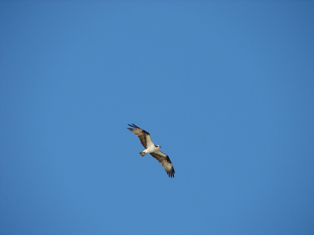
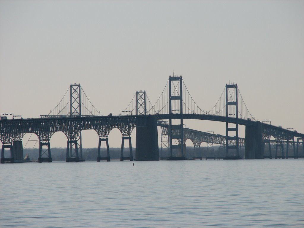
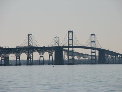 This is a great if hard to find spot. There are no signs that I could see from the main road. You have to drive through a new industrial area to get to it. Here is an aerial photo of the place. There are a few nice spots at this park. They have a pond with two duck blinds. No birds were visible in the pond, but I looked up and spotted a beautiful bird of prey which I later discovered is an Osprey. I had to double check since I thought these were hard to get a glimpse of and there was no such difficulty here. They have an open meadow area which isn’t interesting yet, but it will be soon according to a sign that was present. There is a raised viewing platform suggesting it is worth a return visit. There is a fairly long trail along the beach of the Chesapeake Bay and the Bay Bridge is visible along the entire length as well as the Western Shore. I had the opportunity to watch a southbound container ship as well. There are benches located in several places along the trail including on the beach, so this is a good spot to just sit and watch. Most of the wildlife action was in the pond, however. The best place to park yourself is on the trail that splits the pond. I found the presence of other people in the park would cause bird traffic. That is also where I saw what I think is a beaver and it just kept moving across the pond this way and that. I also scored some excellent shots of a Downy Woodpecker and a Great Blue Heron. But my favorite shots would have to be the beautiful Osprey.
 It is important to note that if you don’t slow down and swivel your head around you’re going to miss some great sights in any place. I would have marched right on by the Downy Woodpecker without noticing it had I not been looking this way and that. I was able to maneuver around on the trail to get some shots and it didn’t hardly pay me any attention. It is also important to find a good potential viewing spot and just stop and be silent and still and something will pop up. Like the turtle in the water that I got a picture of. I tried to get a better picture but it dived underwater with impressive speed when I moved. Also, don’t get bummed out when one of a park’s attractions comes up empty, like the duck blinds did here. Keep looking, be patient, go slow and keep looking around. You may come across something completely unexpected, like I did with the rabbit in the middle of the path.
 Today I went to Terrapin Park on the Eastern Shore in Maryland. It is a part of the Queen Anne’s County Department of Parks. This is another bad park page, but I have to give them credit since it looks like they were trying. But they are due for a massive makeover. This park is the Eastern terminus of the “Cross Island Trail” – the Island being Kent Island (parks map). You do need to take care as there is no sign indicating that you need to step off the paved trail in order to walk the park trails or you could wind up inadvertently walking down the Cross Island Trail.
I was not feeling well this morning and took the day off from work, but wanted to get out for some air and picked what I thought was a tiny park. It turned out to be much bigger than I thought. I’ve gotten some of my most interesting photos wildlife wise from this park. I uploaded pictures of about 4 kinds of birds, a rabbit, some turtles, a frog, an insect and what is probably a beaver. I saw some more kinds of birds some I couldn’t get a picture of and others the pictures weren’t really interesting enough to upload.
 This is a great if hard to find spot. There are no signs that I could see from the main road. You have to drive through a new industrial area to get to it. Here is an aerial photo of the place. There are a few nice spots at this park. They have a pond with two duck blinds. No birds were visible in the pond, but I looked up and spotted a beautiful bird of prey which I later discovered is an Osprey. I had to double check since I thought these were hard to get a glimpse of and there was no such difficulty here. They have an open meadow area which isn’t interesting yet, but it will be soon according to a sign that was present. There is a raised viewing platform suggesting it is worth a return visit. There is a fairly long trail along the beach of the Chesapeake Bay and the Bay Bridge is visible along the entire length as well as the Western Shore. I had the opportunity to watch a southbound container ship as well. There are benches located in several places along the trail including on the beach, so this is a good spot to just sit and watch. Most of the wildlife action was in the pond, however. The best place to park yourself is on the trail that splits the pond. I found the presence of other people in the park would cause bird traffic. That is also where I saw what I think is a beaver and it just kept moving across the pond this way and that. I also scored some excellent shots of a Downy Woodpecker and a Great Blue Heron. But my favorite shots would have to be the beautiful Osprey.
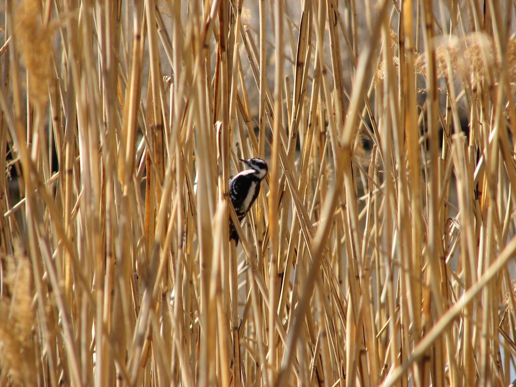 It is important to note that if you don’t slow down and swivel your head around you’re going to miss some great sights in any place. I would have marched right on by the Downy Woodpecker without noticing it had I not been looking this way and that. I was able to maneuver around on the trail to get some shots and it didn’t hardly pay me any attention. It is also important to find a good potential viewing spot and just stop and be silent and still and something will pop up. Like the turtle in the water that I got a picture of. I tried to get a better picture but it dived underwater with impressive speed when I moved. Also, don’t get bummed out when one of a park’s attractions comes up empty, like the duck blinds did here. Keep looking, be patient, go slow and keep looking around. You may come across something completely unexpected, like I did with the rabbit in the middle of the path.
Thursday, March 23, 2006
Photobooks from Digital Images!
Webshots, the place I store my albums online, recently partnered with a company called Qoop to provide people with the ability to print photos from their online albums into photo books, calendars, posters and post cards. I had wanted to send a book of my photos to my grandmother since she does not have a way to see them online. I selected 34 of my images to be turned into a photo book. I picked one photo per page. The cost was pretty reasonable, about $18 for the book and about $4 for shipping. Qoop delivered it within the time frame promised. The first hitch came with DHL. The online tracking system said it had been delivered and signed for so I went to the place where I have things delivered, a UPS Store, and the package was not there and they said DHL had not been there that day. I went home and called DHL to find out what the story is. They lady who answered the phone was polite and after some checking said I would get a call the next day after the driver was contacted. The next morning the UPS Store emailed me to indicate the package had arrived so I went to the store to take a look. DHL called about an hour after the UPS Store emailed me, which is about expected. The lady left a message on my phone (I don’t get a signal in the store) explaining the details and that the package had been delivered to the correct location. Even though Qoop had packaged it fairly well, DHL had managed to bend it so now the book has a crease from the top down about 4 inches.
The book itself is very good. There were some minor artifacts on some of the images, but nothing I would call major, especially for the price. All in all I am very happy with Qoop, not happy at all with DHL considering the package was sent to the wrong place and damaged. The UPS Store continues to make me happy – especially with email package delivery notification. It helped that the DHL folks were polite and patient on the phone, however. Bottom line: I’ll definitely be buying from Qoop again, especially towards the end of the year when it comes time to buy calendars for 2007. I don’t have a choice about DHL since that is their only shipping option.
I have sent the book along to my grandmother. I am hoping it will arrive on Saturday. I am very pleased to have this option available to me so I can share my digital images with my non-connected family members.
Wednesday, March 22, 2006
Fort McHenry 03-19-06
Click here for the Fort McHenry photo album.
I went to two places on Sunday, the B&O Railroad Museum and Fort McHenry National Monument and Historic Shrine. The B&O Railroad Museum requires permission to publish their photos and I am still waiting for it. I will blog the trip to the B&O when I get the permission and post the images.
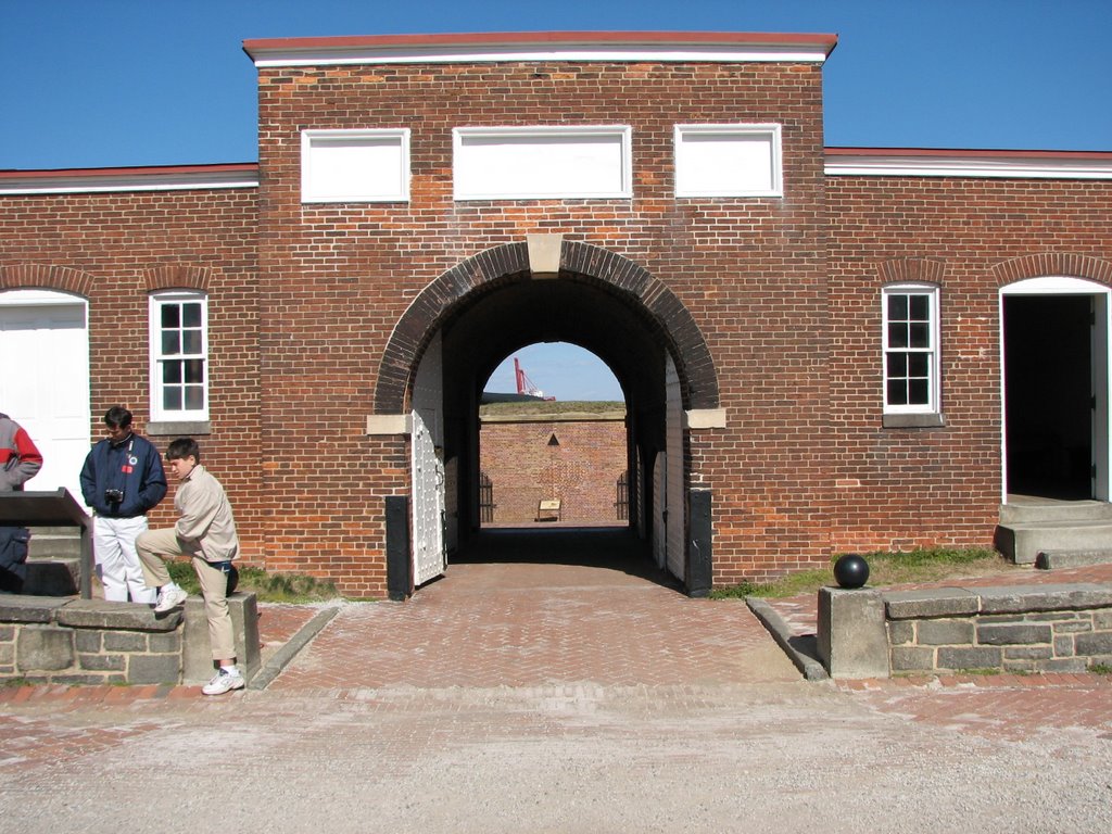
 Fort McHenry (see also, In Depth) in Baltimore, Maryland is a really great place to visit. It has history, industry and a bit of nature and a lot of scenery. You’ve seen me complain before about how badly park services treat their parks on their websites and often leave it up to the individual parks to provide more detailed information. By clicking on In Depth you will see an effort to provide more information. There is a considerable amount of good information on the monument here. As of this writing, the “Last Updated” date is February of this year so it shows someone is making an active effort to maintain the page. In Depth also has a good aerial photo of the site that is good to refer to when viewing some of my photos. Local.live.com also has good aerial photos and bird’s eye views. Using the aerial photos and bird’s eye views can be good if you want to locate some of the features I have photographed.
 It was in the 40s but quite windy the day I went to Fort McHenry. I do not like to go out photographing on windy days because of all the stuff that can be blown onto the lense of my camera. I really loved by visit here. The Fort is beautiful and well kept and has good signage. Some of the exhibits inside the buildings in the Fort are dark and hard to see in, but I think they are making a point. That is what it was like in 1814. The flag pole is a replica of the one that was there when Francis Scott Key wrote “The Star-Spangled Banner” and the flag that was flying the day I was there is smaller than the one he would have seen due to the wind that day. They do have a full size flag and when the wind speed is right, they hoist it up. They don’t use the full size flag all the time because it would cause undue stress on the wood flag pole. Note that the flag has 15 stars and 15 stripes.
 In addition to the features of the Fort, the position of the Fort lends to excellent views of some of the industries around it. I saw quite a lot of ships. Of particular interest to me was the Ro Ro (Roll On-Roll Off) ships. One opened at the nose and the other opened at the rear. According to the Atlantic Ro-Ro Carriers website, they have 7 ships and travel between St. Petersburg, Russia and several US ports, one of which is Baltimore. There were also three big boxy auto carriers and a few other ships. Some industries could be seen on shore as well. I even scored a shot of some covered hopper railroad cars near where the Ro Ro ships were. I also got a very good shot of the WWII Liberty Ship John W. Brown. I thought it might have been a Liberty Ship when I was looking at it, but did not think it was likely. When I looked up Liberty Ship on the web, the website for that ship was the first hit. Read their site if you are unfamiliar with Liberty Ships. They played an important role in WWII.
Also visible from the Fort grounds is the huge Francis Scott Key Bridge. It does not look that large from the Fort, but I drove over it while going to North Point State Park to get pictures and it is huge. I had the opportunity to watch one of the big auto carrying ships pass under it on its way out to the Chesapeake Bay. I had the excellent opportunity also to watch and photograph a pair of tugboats head out from the direction of the Inner Harbor towards the auto carrying ship, once the ship was underway they returned. I got a picture of the two tugs returning along with a pilot boat heading out.
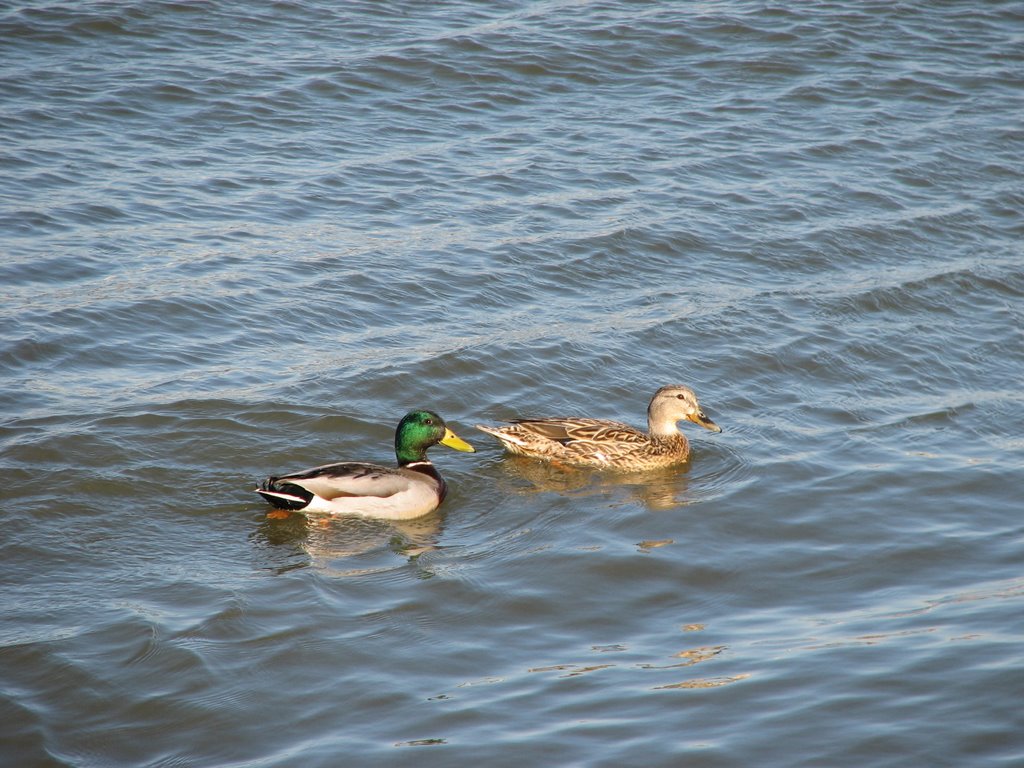
 There were quite a lot of birds around the Fort, mostly waterfowl. I saw three different kinds of ducks, the Bufflehead, the American Wigeon and the Mallard. There were also some Double-Crested Cormorants flying around. I want to stop for a minute and talk about two resources I bought to help me identify birds. I dislike seeing something and not knowing what it is, so I am viewing my adventures as an educational experience as well. The first item I bought is a fold up waterproof “quick-guide” by a company called “Local Birds” – I got it from the Chesapeake Environmental Center. The second is the “Peterson First Guides Birds” book. I felt like it was written specifically for me because the beginning of the book goes into the basics of bird identification which itself is an educational experience on what kinds of birds there are out there. I will definitely be buying more from the Peterson First Guides collection. The book is excellent sized to drop it in a backpack and keep it with you while out on the trail, but I intend to keep it here at home base for identification after I upload the pictures. I bought this book at the Battle Creek Cypress Swamp. So anyway. Before I had these resources, the only bird I could identify was the Mallard. What is interesting is that while the Mallard will dip into the water for lunch, the Wigeon will actually dive. I saw a raft of about 6 of these things off shore and they would disappear from view for 30 seconds at a time.
There is also a trail that winds around the Fort next to the water all the way around. There is also an oddity on the property, a large statue to Orpheus. Read this PDF file to find out why it is there.
This is an excellent if somewhat surreal place to visit. The view over the archaic cannons aiming out to the modern industry can help put a bit of a perspective on how much things have changed.
I went to two places on Sunday, the B&O Railroad Museum and Fort McHenry National Monument and Historic Shrine. The B&O Railroad Museum requires permission to publish their photos and I am still waiting for it. I will blog the trip to the B&O when I get the permission and post the images.
 Fort McHenry (see also, In Depth) in Baltimore, Maryland is a really great place to visit. It has history, industry and a bit of nature and a lot of scenery. You’ve seen me complain before about how badly park services treat their parks on their websites and often leave it up to the individual parks to provide more detailed information. By clicking on In Depth you will see an effort to provide more information. There is a considerable amount of good information on the monument here. As of this writing, the “Last Updated” date is February of this year so it shows someone is making an active effort to maintain the page. In Depth also has a good aerial photo of the site that is good to refer to when viewing some of my photos. Local.live.com also has good aerial photos and bird’s eye views. Using the aerial photos and bird’s eye views can be good if you want to locate some of the features I have photographed.
 It was in the 40s but quite windy the day I went to Fort McHenry. I do not like to go out photographing on windy days because of all the stuff that can be blown onto the lense of my camera. I really loved by visit here. The Fort is beautiful and well kept and has good signage. Some of the exhibits inside the buildings in the Fort are dark and hard to see in, but I think they are making a point. That is what it was like in 1814. The flag pole is a replica of the one that was there when Francis Scott Key wrote “The Star-Spangled Banner” and the flag that was flying the day I was there is smaller than the one he would have seen due to the wind that day. They do have a full size flag and when the wind speed is right, they hoist it up. They don’t use the full size flag all the time because it would cause undue stress on the wood flag pole. Note that the flag has 15 stars and 15 stripes.
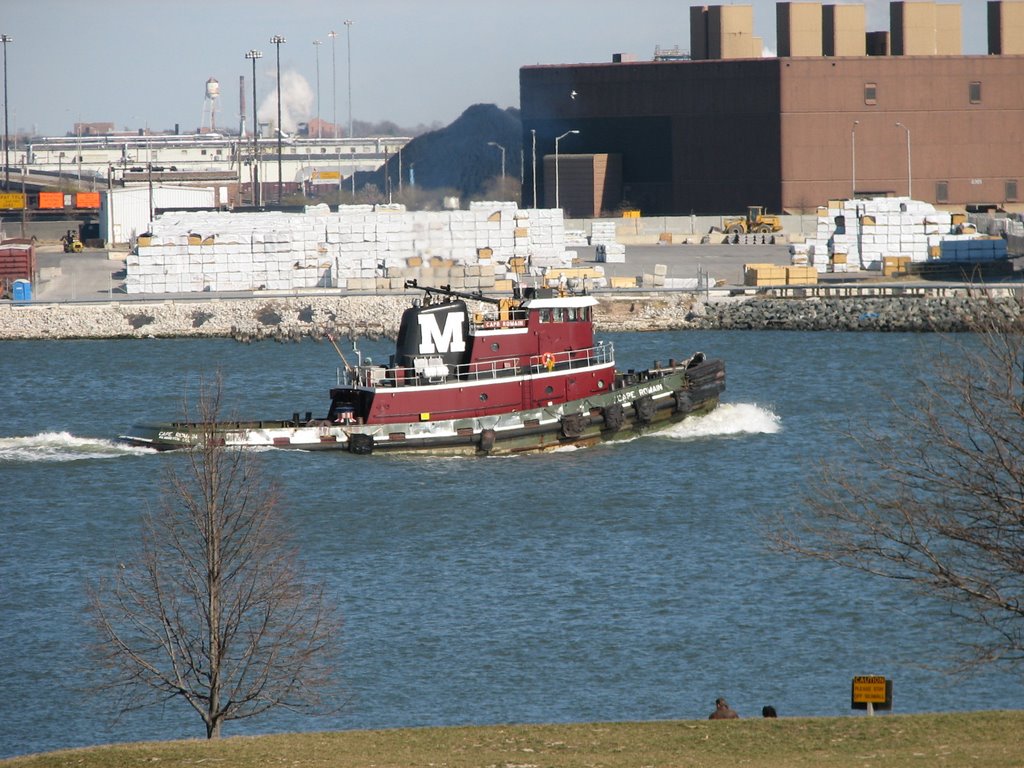 In addition to the features of the Fort, the position of the Fort lends to excellent views of some of the industries around it. I saw quite a lot of ships. Of particular interest to me was the Ro Ro (Roll On-Roll Off) ships. One opened at the nose and the other opened at the rear. According to the Atlantic Ro-Ro Carriers website, they have 7 ships and travel between St. Petersburg, Russia and several US ports, one of which is Baltimore. There were also three big boxy auto carriers and a few other ships. Some industries could be seen on shore as well. I even scored a shot of some covered hopper railroad cars near where the Ro Ro ships were. I also got a very good shot of the WWII Liberty Ship John W. Brown. I thought it might have been a Liberty Ship when I was looking at it, but did not think it was likely. When I looked up Liberty Ship on the web, the website for that ship was the first hit. Read their site if you are unfamiliar with Liberty Ships. They played an important role in WWII.
Also visible from the Fort grounds is the huge Francis Scott Key Bridge. It does not look that large from the Fort, but I drove over it while going to North Point State Park to get pictures and it is huge. I had the opportunity to watch one of the big auto carrying ships pass under it on its way out to the Chesapeake Bay. I had the excellent opportunity also to watch and photograph a pair of tugboats head out from the direction of the Inner Harbor towards the auto carrying ship, once the ship was underway they returned. I got a picture of the two tugs returning along with a pilot boat heading out.
 There were quite a lot of birds around the Fort, mostly waterfowl. I saw three different kinds of ducks, the Bufflehead, the American Wigeon and the Mallard. There were also some Double-Crested Cormorants flying around. I want to stop for a minute and talk about two resources I bought to help me identify birds. I dislike seeing something and not knowing what it is, so I am viewing my adventures as an educational experience as well. The first item I bought is a fold up waterproof “quick-guide” by a company called “Local Birds” – I got it from the Chesapeake Environmental Center. The second is the “Peterson First Guides Birds” book. I felt like it was written specifically for me because the beginning of the book goes into the basics of bird identification which itself is an educational experience on what kinds of birds there are out there. I will definitely be buying more from the Peterson First Guides collection. The book is excellent sized to drop it in a backpack and keep it with you while out on the trail, but I intend to keep it here at home base for identification after I upload the pictures. I bought this book at the Battle Creek Cypress Swamp. So anyway. Before I had these resources, the only bird I could identify was the Mallard. What is interesting is that while the Mallard will dip into the water for lunch, the Wigeon will actually dive. I saw a raft of about 6 of these things off shore and they would disappear from view for 30 seconds at a time.
There is also a trail that winds around the Fort next to the water all the way around. There is also an oddity on the property, a large statue to Orpheus. Read this PDF file to find out why it is there.
This is an excellent if somewhat surreal place to visit. The view over the archaic cannons aiming out to the modern industry can help put a bit of a perspective on how much things have changed.
Saturday, March 11, 2006
Photos From Two Parks in Calvert County, Maryland
Album URLs:
http://www.flickr.com/photos/meabbott/sets/72157605985946943/
http://www.flickr.com/photos/meabbott/sets/72157605985840485/
I haven’t been out to take pictures in a couple of weeks so when I saw the temperatures were going to be warm and the skies sunny, I jumped at the chance to get out. I tried out my new hiking boots I got from L.L. Bean last week. I found them to be very nice, but they’re a little smaller than I thought they were so I will trade them for the next size up. I tried the L.L. Bean Lightweight Cresta Hiking Socks with them and they are terrific. I went to two places today, Battle Creek Cypress Swamp and King’s Landing. These are two of the three parks in the Calvert County Parks system. I didn’t make it to Flag Pond but I will go there another time. In the fine tradition of park system websites, these pages do a tragic disservice to these parks. They don’t describe all of the features of the parks (EG: The website doesn’t describe the kind of Cypress Tree they have, nor does the site indicate they have an arboretum!). I have not yet discovered the reason park services seem to treat their parks so harshly on their websites, but there must be a reason. They all do it. There are some individual parks that have their own pages where they tend to have better information, they seem to be maintained by the folks at the park in question.
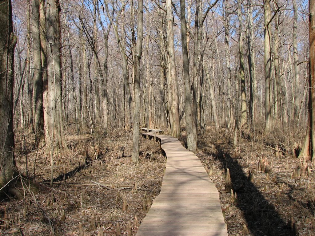
 On to Battle Creek Cypress Swamp. I’d been there once before a few years ago and noted that it was quiet and the air relatively still. The reason for that is that it is in a bit of a valley. It is very pleasant. There is a nice visitor center that describes and has examples of some of the critters you may see, though I saw nothing but birds and some insects except for one frog who made his departure before I could snap a picture. Just as well, he was a muddy fellow. This is a good visitor center and you will want to spend a few moments here before heading onto the trail. Most of the trail is a boardwalk which to me seemed to be very well maintained. It was very firm and felt quite safe. There were a few people walking the boardwalk, but not as many as I had expected given the nice day. But this is kind of an out of the way place. The boardwalk is a loop that leads out into the wetlands and back. The wetlands inside the loop is chaotic with branches and so on where the area outside looked a little bit neater. I am not sure why this is. The bright sun gave me the opportunity to get some good photos from here. Looking through the clear water with the bright sun was especially nice. I took a side trail towards the end which led off the board walk and onto a dirt path. I saw an overturned car and an old house up this way. Back at the center they have some ponds which is a good place to watch for small birds if you hold still and be patient. There is also a Barred Owl which was blind from being hit by a car in a hutch.
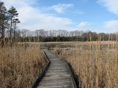 I went on to King’s Landing to see what the deal is there. The place felt more like a community recreation center to me, but if you look at an aerial photo you see about half the park is left to nature. Although there are several activities mentioned on the website, they neglect to mention that there is a swimming pool (obviously not open yet) or an equestrian area. This park has areas set up for people to learn to get their bearings using a compass as well as a trail dedicated to teaching people the various things seen in a forest with labels already on them. I thought this is a great idea that other parks ought to adopt. Not necessarily these ideas specifically, but use their resources as an active practical teaching area. There are plenty of parks that have a ranger or a guest give a lecture or a guided tour on a particular manner, but I haven’t yet seen anything like this. There is a fishing pier present and seems to be the most used part of the park, at least at this time of the year. It gives a nice view to one segment of the highly disjointed Patuxent River Park on the other side of the river. A coal fired power plant along with power lines crossing the river can also be seen looking south along the river. This park has a hidden jewel along one of its trail. From the parking lot next to the swimming pool there is a sign which contains a map of the park and the trails. Even with that, the trail entrance looks like just an opening between the trees and you’d be inclined to continue to follow the gravel trail. Nothing wrong with that, it is a nice walk too. But the trail has no trail marker, no blazes, nothing. Once you get into the trail a little bit you get onto a boardwalk like the one at Battle Creek. It is also steady and well maintained. Following the trail you will come to a spur that leads out into the wetlands and has two benches facing the wetlands. When you approach the benches you will see the boardwalk is twisted, don’t be alarmed, it is solid all the way. This is the jewel I refer to. It is an excellent place to see a variety of activity and I got some OK pictures of a Blue Heron here. It is fairly quiet here and I did not see anybody else on the trail at all. I walked a few other parts of the park, but I had been spoiled by the view from the benches. There is another spur, shorter than this one, that you will come upon first with benches facing each other. This is a nice spot, but I believe they should place an observation tower like the ones I saw at the Chesapeake Environmental Center here instead to give a view over the vegetation.
The lowlands next to the water in both of these places had been inundated fairly recently and looked muddy. A good rain will make these places look a bit more photogenic.
http://www.flickr.com/photos/meabbott/sets/72157605985946943/
http://www.flickr.com/photos/meabbott/sets/72157605985840485/
I haven’t been out to take pictures in a couple of weeks so when I saw the temperatures were going to be warm and the skies sunny, I jumped at the chance to get out. I tried out my new hiking boots I got from L.L. Bean last week. I found them to be very nice, but they’re a little smaller than I thought they were so I will trade them for the next size up. I tried the L.L. Bean Lightweight Cresta Hiking Socks with them and they are terrific. I went to two places today, Battle Creek Cypress Swamp and King’s Landing. These are two of the three parks in the Calvert County Parks system. I didn’t make it to Flag Pond but I will go there another time. In the fine tradition of park system websites, these pages do a tragic disservice to these parks. They don’t describe all of the features of the parks (EG: The website doesn’t describe the kind of Cypress Tree they have, nor does the site indicate they have an arboretum!). I have not yet discovered the reason park services seem to treat their parks so harshly on their websites, but there must be a reason. They all do it. There are some individual parks that have their own pages where they tend to have better information, they seem to be maintained by the folks at the park in question.
 On to Battle Creek Cypress Swamp. I’d been there once before a few years ago and noted that it was quiet and the air relatively still. The reason for that is that it is in a bit of a valley. It is very pleasant. There is a nice visitor center that describes and has examples of some of the critters you may see, though I saw nothing but birds and some insects except for one frog who made his departure before I could snap a picture. Just as well, he was a muddy fellow. This is a good visitor center and you will want to spend a few moments here before heading onto the trail. Most of the trail is a boardwalk which to me seemed to be very well maintained. It was very firm and felt quite safe. There were a few people walking the boardwalk, but not as many as I had expected given the nice day. But this is kind of an out of the way place. The boardwalk is a loop that leads out into the wetlands and back. The wetlands inside the loop is chaotic with branches and so on where the area outside looked a little bit neater. I am not sure why this is. The bright sun gave me the opportunity to get some good photos from here. Looking through the clear water with the bright sun was especially nice. I took a side trail towards the end which led off the board walk and onto a dirt path. I saw an overturned car and an old house up this way. Back at the center they have some ponds which is a good place to watch for small birds if you hold still and be patient. There is also a Barred Owl which was blind from being hit by a car in a hutch.
 I went on to King’s Landing to see what the deal is there. The place felt more like a community recreation center to me, but if you look at an aerial photo you see about half the park is left to nature. Although there are several activities mentioned on the website, they neglect to mention that there is a swimming pool (obviously not open yet) or an equestrian area. This park has areas set up for people to learn to get their bearings using a compass as well as a trail dedicated to teaching people the various things seen in a forest with labels already on them. I thought this is a great idea that other parks ought to adopt. Not necessarily these ideas specifically, but use their resources as an active practical teaching area. There are plenty of parks that have a ranger or a guest give a lecture or a guided tour on a particular manner, but I haven’t yet seen anything like this. There is a fishing pier present and seems to be the most used part of the park, at least at this time of the year. It gives a nice view to one segment of the highly disjointed Patuxent River Park on the other side of the river. A coal fired power plant along with power lines crossing the river can also be seen looking south along the river. This park has a hidden jewel along one of its trail. From the parking lot next to the swimming pool there is a sign which contains a map of the park and the trails. Even with that, the trail entrance looks like just an opening between the trees and you’d be inclined to continue to follow the gravel trail. Nothing wrong with that, it is a nice walk too. But the trail has no trail marker, no blazes, nothing. Once you get into the trail a little bit you get onto a boardwalk like the one at Battle Creek. It is also steady and well maintained. Following the trail you will come to a spur that leads out into the wetlands and has two benches facing the wetlands. When you approach the benches you will see the boardwalk is twisted, don’t be alarmed, it is solid all the way. This is the jewel I refer to. It is an excellent place to see a variety of activity and I got some OK pictures of a Blue Heron here. It is fairly quiet here and I did not see anybody else on the trail at all. I walked a few other parts of the park, but I had been spoiled by the view from the benches. There is another spur, shorter than this one, that you will come upon first with benches facing each other. This is a nice spot, but I believe they should place an observation tower like the ones I saw at the Chesapeake Environmental Center here instead to give a view over the vegetation.
The lowlands next to the water in both of these places had been inundated fairly recently and looked muddy. A good rain will make these places look a bit more photogenic.
![]()